Sunday, 29 December 2013

Bremen Core Repository!

Just before Christmas some fellow students, several lecturers and myself travelled to Bremen Core Repository in Germany to experience what it would be like to log igneous rock cores which were drilled from the ocean floor.


The picture above shows some of the cores which we looked at. These are all igneous rocks which were drilled from the ocean floor by research ships such as the JOIDES Resolution shown below.


But perhaps one of the most interesting cores is the one shown below which captures a slice of time right through the period where dinosaurs went extinct, which is known as the KT boundary.


This core has an iridium rich layer at the top of the green band which scientists believe formed from the asteroid impact which killed off the dinosaurs. Iridium is a rare element on Earth but it is plentiful in asteroids which is strong evidence for a meteorite impact being responsible for the extinction of the dinosaurs.

All of the cores at the repository were divided length ways into two giving a working half and an archive half. The working half could be sampled for scientists to study for research into all sorts of areas (such as palaeomagnetic analysis or microbiology). The archive half is also accessible for study but no samples or altering of this half can be done so that there is always a record kept of the cores in case other people want to study them in the future.

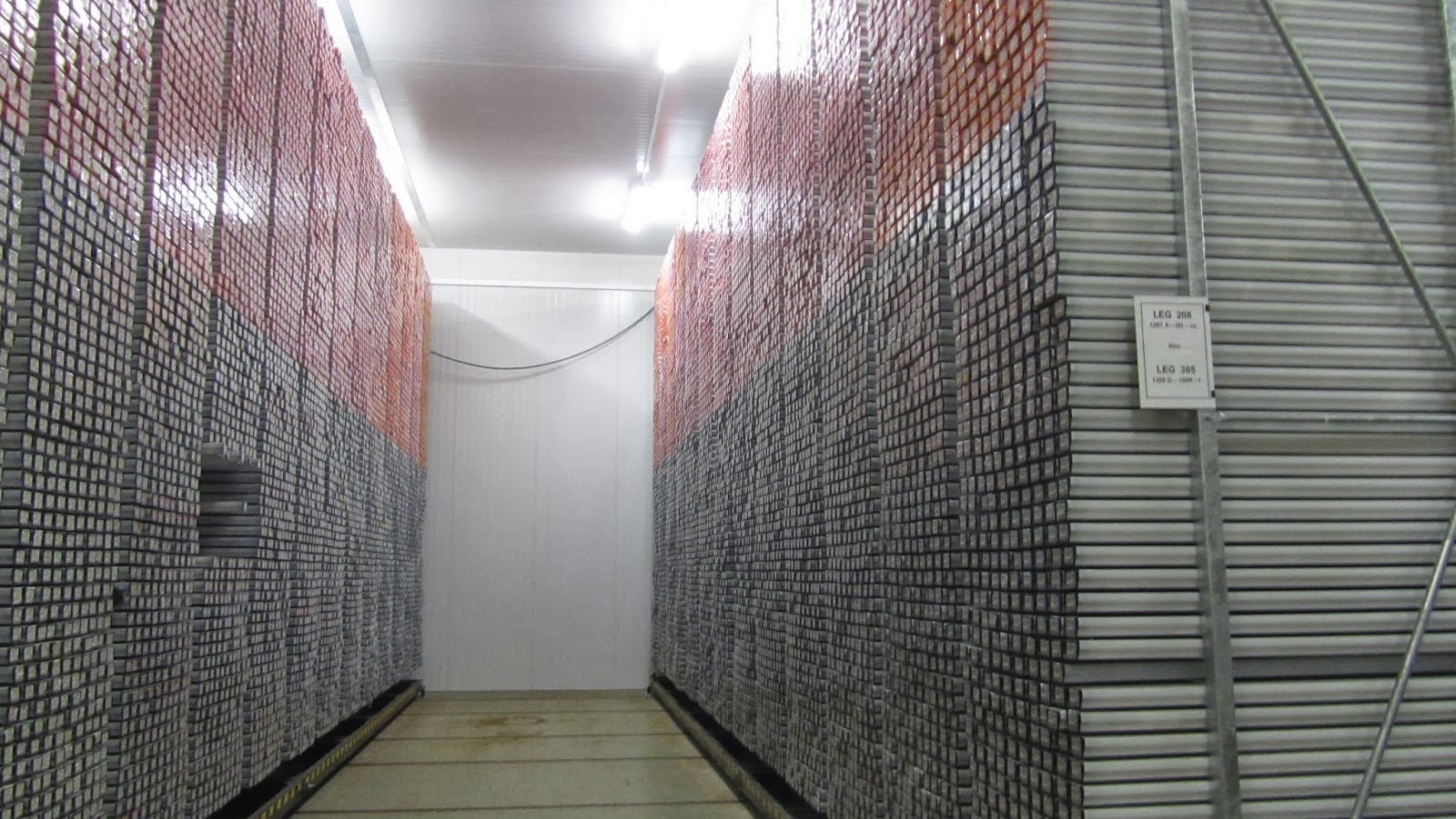
All of the cores were kept in a large room (shown below) which was kept at 4°C, but luckily we didn't spend that long in there and spent most of the days working in a much warmer lab next door!


On our visit we logged the mineralogy and textures, geological structures (such as faults) and metamorphic alteration to the minerals which we could see in the cores. I found this exercise very interesting and it was an exciting thought that once these rocks would have been buried deep beneath the ocean, and modern technologies now mean that we can extract rocks from the Earths interior and from beneath km's of ocean!

Reports for many drilling expeditions can be found on the International Ocean Drilling Programme (IODP) website if you use the search bar at the top. There is also more information about the core repository, events happening there and an interactive map showing where cores have been extracted from:

http://www.marum.de/en/IODP_Bremen_Core_Repository.html

I strongly encourage you to follow the link above and take a look for yourself!

Happy reading!


Monday, 23 December 2013

Diamonds in Antarctica!


Catching up on geology in the news this afternoon and an article called 'New findings hint at diamond deposits in Antarctica' caught me eye.

Research soon to be published in Nature details how diamond bearing rocks called kimberlites have been found in small amounts at Mount Meredith in the northern Prince Charles Mountains, shown on the map below.


Kimberlite rocks are igneous rocks which form at depths of 150 km to 450km depth. They are erupted very rapidly and violently often with the release of carbon dioxide and other volatile gases. The rocks are the source of not just diamonds but also other precious stones such as garnet and spinel.


Although the potential for mining diamonds in Antarctica might exist, there are international laws which currently prevent any exploitation of mineral resources in Antarctica except for scientific purposes. One such act is the 'Protocol on Environmental Protection to the Antarctic Treaty'. So for now we will just have to wait and see, I guess we won't truely know what lies beneath the vast ice sheets of Antarctica until the majority of the ice has melted, and that will be a while...

For further reading try these links below:

http://www.bbc.co.uk/news/science-environment-25417441
http://ossfoundation.us/projects/environment/global-warming/antarctic-ice-melt

Happy Reading!

Friday, 13 December 2013

Geology...in Films!


For those of you that don’t know it, today was the release date for The Hobbit: The Desolation of Smaug which may not be everybody’s cup of tea (it certainly is mine), but no matter what your kind of movie is, I bet that somewhere in it there is geology.

This isn’t the first time this has crossed my mind but I thought seeing as I am doing a blog, now would be a good time to mention it.

Geology is in films. And I don’t meant films about geology like Iain Stewart on TV, I mean films about the hero that goes on a journey and ends up saving the day, or a film where a serial killer is on the loose trying to kill the main character because “he knows too much”.

I couldn’t help but notice the scene in Due Date which is set in the spectacular Grand Canyon in America and you can see the horizontal bedding which has been exposed because of the river cutting a valley don through the geology.


A lot of epic films like Lord of the Rings have scenes which zoom out and show epic scenes of natural beauty. Sometimes people even sort this out when picking a film to watch, which is why review website IMDb has a section specifically for ‘Films Featuring Natural Scenic Beauty’. Looking through the list the first few I recognise are Lord of the Rings, The Sound of Music and Stardust but there are many more which contain scenes of geology. To be honest, most films which have an element of the outdoors or nature in probably have geology in there somewhere.

Sometimes rocks are even important objects in films, for instance Harry Potter and the Philosphers Stone. Granted it’s not quite the same as that rock was created by people not nature but the principle is there.


Or for anyone that watches or has read A Game of Thrones, the blade made out of dragon glass used for killing White Walkers is actually obsidian! Which is basically glass which cools very quickly when erupted from a volcano!


So I implore you to take a look next time you are watching a film, and see if there are any cool looking rock outcrops or props that link to geology.

Happy reading!


Sunday, 8 December 2013

The uses of the magnetic field...


We have all used magnets at some point whether its on your fridge door or a mobile phone case, but do you know how they work or why they work or why magnetic fields are so important?


Our Earth has a magnetic field around it which is self-sustaining due to the semi-molten composition of parts of the inner Earth. The axis of the magnet is offset from the Earth's rotation by around 11 degrees which means that the magnetic north and south poles are not in the same positions as the geographical north and south poles. Not only this but the strength of the magnetic field varies across the Earth too.


So knowing this I bet you're wondering what this has to do with geology? Well as you know, some metals are more magnetic than others, so by doing geomagnetic surveying using specialised equipment we can essentially 'map' the sub-surface and locate bodies of ore which could potentially be mined.


Magnetic surveying is also done for oil exploration and in archaeology to detect buried artefacts, grave sites and building remnants, such as the site map of magnetic data shown above. 

We can also use it for dating rocks. In the past, the Earth's magnetic field has flipped, so magnetic north has been at the south and vice versa. Scientists are still not sure why the Earth does this but it can do it quite erratically and either lots or very rarely. This is particularly notable at mid-ocean ridges where plate divergence is occurring and new rocks are being generated which get magnetised to magnetic north as they cool, so the magnetic pattern preserved in the rocks across the ocean floor preserve a record for magnetic field reversals, and because we have dated these rocks (so know how old they are) we can piece together a history for the magnetic field of our Earth.

So there you go. We are all sat inside one giant magnetic field which is useful for geological reasons as well as many others. Of course it does other more essential things, such as protect the Earth from the deadly solar winds which would otherwise make life on Earth impossible, but I thought it was important to mention its geological uses too.

More information can be found at:


Happy reading!


Friday, 29 November 2013

Geology in the Headlines!

So if you’ve been tracking my blog you will have noticed that I have pointed out many ways which show that geology is not just about rocks.
To prove just how diverse this subject is, here is a list of some headline news from just this week which are part of geology:

1.       Giant prehistoric toilet unearthed (BBC News)
Now this headline would catch anyone’s eye. I don’t know about you but when I first saw this I imagined quite literally a large (and smelly) place where prehistoric animals went to go and do their business. But when you read the story, you go on to learn more about a specific species which left these traces.


These dinosaurs were called dicynodonts which were large mammal-like reptiles whose diet was entirely plants, making them megaherbivores.  Dinosaur poo which has been preserved is called a coprolite, and in this case they discovered coprolites up to 40cm wide! Finding these is fantastic news for any palaeontologist as they can provide clues to the environment that the animal was in at the time such as; the vegetation around, the food chain and even animal behaviour. Because faeces degrade so easily, finding a site with such good preservation of coprolites was very exciting for the scientific community, and because the story is so relevant to any animals (including us), it makes for a fantastic read:

2.       Last-minute deal saves fractious UN climate talks (BBC News)
So this story might sound a little dry, but the background story behind this is that the UN is trying to find ways to reduce the negative effects which developed and developing countries may be having on the changing climate. Behind this debate, there are geologists studying past climate change who are researching the effects, timing and frequency of these events to find out as much as possible about how climate change is controlled.   

3.       Indonesia raises Sumatra volcano alert to highest status
Now this one is a bit more exciting! Mount Sinabung has been showing signs of eruption recently which means and so the local authorities have been raised from "stand-by" to "caution". This has meant drastic changes for local people who are advised not to go closer than 5km away from the crater and 15,000 villagers in the area have been moved to temporary shelters. As you can imagine this brings masses of disruption to everyday life for these people and it is up to the scientists (including geologists) to determine when it is safe for them to return to their homes.


These are but a few examples this week of how geology and being able to communicate it fit into real world scenarios. Keep an eye out, and when you see an interesting story, take a minute to consider if there is a connection to geoscience, I bet you’ll be surprised by how often there is.

Happy reading!


Wednesday, 20 November 2013

Mt Merapi School Visit and the CRES Conference!

So today has been quite an exciting one for geoscience communication...

This morning

The day kicked off with a school visit from Kelly College students (local to Plymouth, UK) who had come into Plymouth University just for the morning to do a volcanic hazard session. This involved the students acting as an expert team trying to deal with the hazards of an impending volcanic eruption as and when activities occurred. Each team had three members; a geologist, information co-ordinator and decision maker who needed to work together to make the best decision to minimise the risks associated with the hazard. All of the teams worked well and effectively communicated via posters and radio broadcasts to the communities residing on the volcano.

This was an enjoyable exercise and a great way to get children interested in geology, and this made me think about volcano warning systems in real scenarios. The basic requirements for an effective warning system are:
- Information has to be easily readable.
- The system has to be user friendly.
- The user must have trust in the system to give accurate information.

All of these points have been covered in the GEOWARN Atlas Information System, the key information of which is shown in this image:


This system works excellently as it can be implemented into any volcano hazard program of organizations dealing with hazard assessment and crisis management, without dependence on expensive software. Further information about the development of this system can be read here:


This afternoon

This afternoon was the CRES (Centre for Research in Earth Sciences) Conference at Plymouth University, where academic staff, students and guest speakers gave short talks about their current research projects. It was fascinating whether you were interested in fossils, climate change, minerals, volcanoes or science communication (or all of them!)

These conferences happen every year and it seems that every year I discover some new aspect of geology which I didn't know about before.

For instance I didn't know that research on characterising mineral surfaces through adsorption may be applied to you and me! For example, if this research identifies definite results, it could eventually lead to the development of research into slow release drugs or long lasting flavours in chewing gum. And this is just one way that geological research could positively effect everyday life.

Most universities, colleges and interest groups hold these conferences and events so if you are interested in attending one, I strongly encourage you to investigate your local organisations. You never know you might discover an interest in something which you didn't even know about!

Happy reading!

Sunday, 17 November 2013

Everyday Geology

So far in this blog I have been talking about some of the uses of geology, but I thought it would be good to mention some of the most common uses of different types of rocks.

So lets look at some of the most common things in everyday life and see what they are made of.


Roads. We all use them even if we don't have a car or motorcycle, for walking, the bus or cycling. One of the key ingredients to making the material which is used on roads is basalt. Basalt is an igneous rock formed from rapid cooling of lava. It is then processed to be used and combined with other materials to make road surfaces.


Monuments, sculptures, tombstones and buildings. These can be made of a variety of rock types but the most common ones are granite and marble. Granite is an intrusive igneous rock (i.e. was hot rock which slowly cooled and solidifies below the Earths surface). It is a very common rock within the continental crust.
Marble is very different. It is a metamorphic rock composed of recrystallised calcite or dolomite, commonly metamorphosed limestone.


Exfoliating scrubs. These are very light and made of pumice. Pumice is volcanic rock which contains lots of air pockets called vesicles. It looks like foam but is a hard and airy rock which is great for scouring, scrubbing and polishing other surfaces.


Roof tiles. Made of slate. Slate is an metamorphic rock and the heat and pressure which altered the rock and gave it its platey property make it an appropriate material for use on roofs.

So that was a brief look at some common objects we see everyday and what they are made of. I hope this has made you interested in what other everyday items are made of and I hope you are interested enough to go and find out more for yourself.

Happy reading!